Thank you for supporting this site ❤️
Make a donation
Make a donation
Gear up for your next adventure:
As an Amazon Associate, this site earns from qualifying purchases at no extra cost to you.
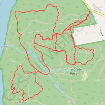
Hurd Park Mountain Bike Loop
Interactive trail map
Thank you for supporting this site ❤️
Make a donation
Make a donation
Gear up for your next adventure:
As an Amazon Associate, this site earns from qualifying purchases at no extra cost to you.
Trail profile
- Distance: 11.8 Km
- Elevation gain: 250 m
- Maximum elevation: 141 m
- Elevation loss: 250 m
- Minimum elevation: 35 m
- Moving time: 59 m 16 s
- Moving speed: 12.0 Km/h
- Maximum speed: 32.4 Km/h
- Total time: 1 h 3 m
- Global speed: 11.2 Km/h
Thank you for supporting this site ❤️
Make a donation
Make a donation
Gear up for your next adventure:
As an Amazon Associate, this site earns from qualifying purchases at no extra cost to you.
About this trail
Name: Hurd Park Mountain Bike Loop trail, distance, elevation, map, profile, GPS track
Coordinates: 41.51766 -72.55152 41.53092 -72.53644
Thank you for supporting this site ❤️
Make a donation
Make a donation
Gear up for your next adventure:
As an Amazon Associate, this site earns from qualifying purchases at no extra cost to you.