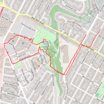
Walk across new suspension bridge to Signature Park across Shoal Creek
- Distance: 3.6 Km
- Elevation gain: 49 m
- Maximum elevation: 206 m
- Elevation loss: 47 m
- Minimum elevation: 177 m
- Moving time: 46 m 10 s
- Moving speed: 4.7 Km/h
- Maximum speed: 16.4 Km/h
- Total time: 54 m 33 s
- Global speed: 4.0 Km/h
Interactive trail map
Trail profile
- Distance: 3.6 Km
- Elevation gain: 49 m
- Maximum elevation: 206 m
- Elevation loss: 47 m
- Minimum elevation: 177 m
- Moving time: 46 m 10 s
- Moving speed: 4.7 Km/h
- Maximum speed: 16.4 Km/h
- Total time: 54 m 33 s
- Global speed: 4.0 Km/h
About this trail
Name: Walk across new suspension bridge to Signature Park across Shoal Creek trail, distance, elevation, map, profile, GPS track
Coordinates: 30.31441 -97.75507 30.31898 -97.74397
Other hiking, mountain biking, running and outdoor activity trails
Click on a trail to view its statistics, map and profile.
Bike ride, fresh trail to Manor
United States > Texas > Travis County > Austin
Crowdstruck
Distance: 60.3 Km • Elevation gain: 396 m • Maximum elevation: 207 m