Mount Pierce via Crawford Path in White Mountain National Forest
Hiking Mount Pierce via Crawford Path offers a rewarding and picturesque experience in New Hampshire's White Mountains. The route takes hikers through varied landscapes, from the forested sections near Gibbs Falls to the open, expansive views at the summit. Along the way, the trail provides glimpses of distant peaks and dramatic ridgelines, especially near the top, where the views span across the Presidential Range. The final push to the summit is marked by wide-open ledges, with sweeping vistas that are especially striking on clear days. #Hiking #Mountain #Forest #Nature #Waterfall
- Distance: 9.9 Km
- Elevation gain: 734 m
- Maximum elevation: 1,304 m
- Elevation loss: 733 m
- Minimum elevation: 570 m
- Moving time: 3 h 9 m
- Moving speed: 3.1 Km/h
- Maximum speed: 5.6 Km/h
- Total time: 4 h 38 m
- Global speed: 2.1 Km/h
Interactive trail map
Trail profile
- Distance: 9.9 Km
- Elevation gain: 734 m
- Maximum elevation: 1,304 m
- Elevation loss: 733 m
- Minimum elevation: 570 m
- Moving time: 3 h 9 m
- Moving speed: 3.1 Km/h
- Maximum speed: 5.6 Km/h
- Total time: 4 h 38 m
- Global speed: 2.1 Km/h
About this trail
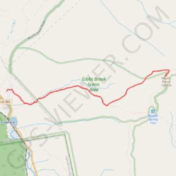
Name: Mount Pierce via Crawford Path in White Mountain National Forest trail, distance, elevation, map, profile, GPS track
Coordinates: 44.22044 -71.41162 44.22785 -71.36478
Other hiking, mountain biking, running and outdoor activity trails
Click on a trail to view its statistics, map and profile.
Presidential Range Traverse
United States > New Hampshire > Coos County > Bowman
Starting near the northern gateway of the Presidential Range, this traverse climbs from the forests of the White Mountain National Forest to the exposed ridgeline of Mount Madison, then continues over the rugged summits of Mount Adams and Mount Jefferson, with wide views across the Great Gulf and the…
Distance: 32.3 Km • Elevation gain: 2,545 m • Maximum elevation: 1,911 m