Horsetail Falls via Deer Creek-Dry Creek Trail in Lone Peak Wilderness
The hike to Horsetail Falls via the Deer Creek-Dry Creek Trail offers a rewarding blend of natural beauty and adventure. The trail meanders through a wooded canyon and opens up to sweeping views of Alpine, Utah Lake, the rugged cliffs of the Lone Peak Wilderness, and nearby peaks like The Pfeifferhorn or White Baldy. The cascading Horsetail Falls is a striking focal point, perfect for a scenic break, though the final ascent involves a steep, occasionally slippery scramble, adding a touch of challenge for adventurous hikers. #Hiking #Mountain #Forest #Nature #Waterfall #Canyon
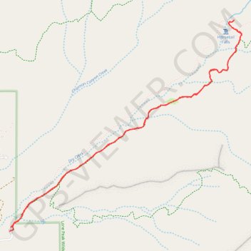
- Distance: 6.7 Km
- Elevation gain: 518 m
- Maximum elevation: 2,248 m
- Elevation loss: 522 m
- Minimum elevation: 1,725 m
- Moving time: 2 h 9 m
- Moving speed: 3.1 Km/h
- Maximum speed: 7.8 Km/h
- Total time: 2 h 32 m
- Global speed: 2.6 Km/h
Interactive trail map
Trail profile
- Distance: 6.7 Km
- Elevation gain: 518 m
- Maximum elevation: 2,248 m
- Elevation loss: 522 m
- Minimum elevation: 1,725 m
- Moving time: 2 h 9 m
- Moving speed: 3.1 Km/h
- Maximum speed: 7.8 Km/h
- Total time: 2 h 32 m
- Global speed: 2.6 Km/h
About this trail
Name: Horsetail Falls via Deer Creek-Dry Creek Trail in Lone Peak Wilderness trail, distance, elevation, map, profile, GPS track
Start: Deer Creek-Dry Creek Trail, Utah County, Utah, 84004, United States (40.48295 -111.75030)
End: Dry Creek Canyon Road, Utah County, Utah, 84004, United States (40.48263 -111.75044)
Coordinates: 40.48263 -111.75044 40.49977 -111.72573
Other hiking, mountain biking, running and outdoor activity trails
Click on a trail to view its statistics, map and profile.