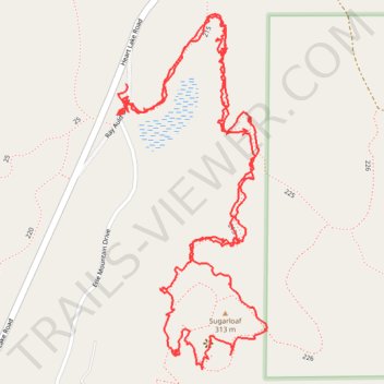
Around Sugarloaf Mountain, WA
- Distance: 4.5 Km
- Elevation gain: 221 m
- Maximum elevation: 312 m
- Elevation loss: 223 m
- Minimum elevation: 128 m
- Moving time: 1 h 10 m
- Moving speed: 3.8 Km/h
- Maximum speed: 32.3 Km/h
- Total time: 1 h 45 m
- Global speed: 2.6 Km/h
Interactive trail map
Trail profile
- Distance: 4.5 Km
- Elevation gain: 221 m
- Maximum elevation: 312 m
- Elevation loss: 223 m
- Minimum elevation: 128 m
- Moving time: 1 h 10 m
- Moving speed: 3.8 Km/h
- Maximum speed: 32.3 Km/h
- Total time: 1 h 45 m
- Global speed: 2.6 Km/h
About this trail
Name: Around Sugarloaf Mountain, WA trail, distance, elevation, map, profile, GPS track
Start: Ray Auld Drive, Anacortes, Skagit County, Washington, 98221, United States (48.46828 -122.62954)
End: Ray Auld Drive, Anacortes, Skagit County, Washington, 98221, United States (48.46773 -122.62973)
Coordinates: 48.46257 -122.62981 48.46967 -122.62529