Thank you for supporting this site ❤️
Make a donation
Make a donation
Gear up for your next adventure:
As an Amazon Associate, this site earns from qualifying purchases at no extra cost to you.
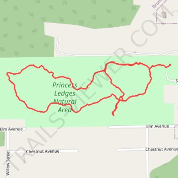
Princess Ledges Nature Reserve
- Distance: 2.2 Km
- Elevation gain: 47 m
- Maximum elevation: 363 m
- Elevation loss: 56 m
- Minimum elevation: 323 m
- Moving time: 26 m 41 s
- Moving speed: 4.9 Km/h
- Maximum speed: 8.0 Km/h
- Total time: 27 m 20 s
- Global speed: 4.8 Km/h
Interactive trail map
Thank you for supporting this site ❤️
Make a donation
Make a donation
Gear up for your next adventure:
As an Amazon Associate, this site earns from qualifying purchases at no extra cost to you.
Trail profile
- Distance: 2.2 Km
- Elevation gain: 47 m
- Maximum elevation: 363 m
- Elevation loss: 56 m
- Minimum elevation: 323 m
- Moving time: 26 m 41 s
- Moving speed: 4.9 Km/h
- Maximum speed: 8.0 Km/h
- Total time: 27 m 20 s
- Global speed: 4.8 Km/h
Thank you for supporting this site ❤️
Make a donation
Make a donation
Gear up for your next adventure:
As an Amazon Associate, this site earns from qualifying purchases at no extra cost to you.
About this trail
Name: Princess Ledges Nature Reserve trail, distance, elevation, map, profile, GPS track
Coordinates: 41.26369 -81.85040 41.26556 -81.84275
Thank you for supporting this site ❤️
Make a donation
Make a donation
Gear up for your next adventure:
As an Amazon Associate, this site earns from qualifying purchases at no extra cost to you.