Vista Verde Viewpoint
Hike to Vista Verde Viewpoint above the Rio Grande via Vista Verde Trail in the Rio Grande Gorge and the Rio Grande del Norte National Monument. #Hiking #River #Overlook #Nature
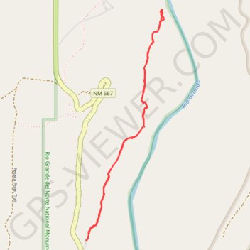
- Distance: 3.8 Km
- Elevation gain: 83 m
- Maximum elevation: 1,935 m
- Elevation loss: 83 m
- Minimum elevation: 1,901 m
- Moving time: 2 h 22 m
- Moving speed: 1.6 Km/h
- Maximum speed: 3.0 Km/h
- Total time: 3 h 28 m
- Global speed: 1.1 Km/h
Interactive trail map
Trail profile
- Distance: 3.8 Km
- Elevation gain: 83 m
- Maximum elevation: 1,935 m
- Elevation loss: 83 m
- Minimum elevation: 1,901 m
- Moving time: 2 h 22 m
- Moving speed: 1.6 Km/h
- Maximum speed: 3.0 Km/h
- Total time: 3 h 28 m
- Global speed: 1.1 Km/h
About this trail
Name: Vista Verde Viewpoint trail, distance, elevation, map, profile, GPS track
Start: La Vista Verde Trailhead Access, Taos County, New Mexico, United States (36.34192 -105.73623)
End: La Vista Verde Trailhead Access, Taos County, New Mexico, United States (36.34191 -105.73624)
Coordinates: 36.34191 -105.73624 36.35668 -105.73008