Thank you for supporting this site ❤️
Make a donation
Make a donation
Gear up for your next adventure:
As an Amazon Associate, this site earns from qualifying purchases at no extra cost to you.
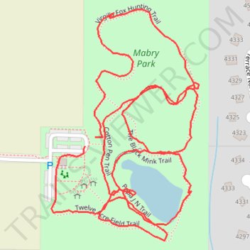
Mabry Park Loop
- Distance: 2.3 Km
- Elevation gain: 30 m
- Maximum elevation: 345 m
- Elevation loss: 29 m
- Minimum elevation: 328 m
- Moving time: 29 m
- Moving speed: 4.8 Km/h
- Maximum speed: 8.5 Km/h
- Total time: 30 m 34 s
- Global speed: 4.6 Km/h
Interactive trail map
Thank you for supporting this site ❤️
Make a donation
Make a donation
Gear up for your next adventure:
As an Amazon Associate, this site earns from qualifying purchases at no extra cost to you.
Trail profile
- Distance: 2.3 Km
- Elevation gain: 30 m
- Maximum elevation: 345 m
- Elevation loss: 29 m
- Minimum elevation: 328 m
- Moving time: 29 m
- Moving speed: 4.8 Km/h
- Maximum speed: 8.5 Km/h
- Total time: 30 m 34 s
- Global speed: 4.6 Km/h
Thank you for supporting this site ❤️
Make a donation
Make a donation
Gear up for your next adventure:
As an Amazon Associate, this site earns from qualifying purchases at no extra cost to you.
About this trail
Name: Mabry Park Loop trail, distance, elevation, map, profile, GPS track
Start: Cotton Pen Trail, Cobb County, Georgia, 30075, United States (34.05696 -84.42997)
End: Cotton Pen Trail, Cobb County, Georgia, 30075, United States (34.05683 -84.43016)
Coordinates: 34.05545 -84.43075 34.05883 -84.42815
Thank you for supporting this site ❤️
Make a donation
Make a donation
Gear up for your next adventure:
As an Amazon Associate, this site earns from qualifying purchases at no extra cost to you.