
Tubbs Hill Loop in Coeur d'Alene
Tubbs Hill Loop offers a scenic and accessible hike with stunning views of Lake Coeur d'Alene throughout most of the trail. The path winds through forested areas and along the lake's edge, passing beaches and rocky outcrops, providing several spots for swimming or just enjoying the natural beauty. It's a popular, family-friendly trail right near downtown, making it easy to explore both the natural and urban environments in one outing. #Hiking #Loop #Lake #Forest #Nature
- Distance: 3.3 Km
- Elevation gain: 110 m
- Maximum elevation: 718 m
- Elevation loss: 112 m
- Minimum elevation: 650 m
- Moving time: 58 m 19 s
- Moving speed: 3.4 Km/h
- Maximum speed: 5.9 Km/h
- Total time: 59 m 34 s
- Global speed: 3.3 Km/h
Interactive trail map
Trail profile
- Distance: 3.3 Km
- Elevation gain: 110 m
- Maximum elevation: 718 m
- Elevation loss: 112 m
- Minimum elevation: 650 m
- Moving time: 58 m 19 s
- Moving speed: 3.4 Km/h
- Maximum speed: 5.9 Km/h
- Total time: 59 m 34 s
- Global speed: 3.3 Km/h
About this trail
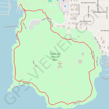
Name: Tubbs Hill Loop in Coeur d'Alene trail, distance, elevation, map, profile, GPS track
Start: Main Trail, Coeur d'Alene, Kootenai County, Idaho, United States (47.67043 -116.78182)
Coordinates: 47.66177 -116.78287 47.67071 -116.77219