Black Elk Peak Trail in Black Hills National Forest
The Black Elk Peak Trail offers a fantastic hiking experience that combines natural beauty and cultural significance. Starting from Sylvan Lake, the trail winds through dense pine forests, rugged granite formations, and features the famous Cathedral Spires. The climb is moderately challenging, with rewarding views of the Black Hills stretching for miles, and at the summit, you'll be greeted by a historic fire tower that offers panoramic vistas. This hike not only delivers breathtaking scenery but also connects hikers to the rich spiritual history of the Lakota people, making it a memorable and meaningful adventure. #Hiking #Mountain #Forest #Nature
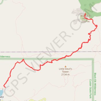
- Distance: 10.9 Km
- Elevation gain: 458 m
- Maximum elevation: 2,185 m
- Elevation loss: 458 m
- Minimum elevation: 1,882 m
- Moving time: 3 h 10 m
- Moving speed: 3.4 Km/h
- Maximum speed: 7.0 Km/h
- Total time: 3 h 55 m
- Global speed: 2.8 Km/h
Interactive trail map
Trail profile
- Distance: 10.9 Km
- Elevation gain: 458 m
- Maximum elevation: 2,185 m
- Elevation loss: 458 m
- Minimum elevation: 1,882 m
- Moving time: 3 h 10 m
- Moving speed: 3.4 Km/h
- Maximum speed: 7.0 Km/h
- Total time: 3 h 55 m
- Global speed: 2.8 Km/h
About this trail
Name: Black Elk Peak Trail in Black Hills National Forest trail, distance, elevation, map, profile, GPS track
Coordinates: 43.84658 -103.56061 43.86598 -103.52672
Other hiking, mountain biking, running and outdoor activity trails
Click on a trail to view its statistics, map and profile.
Black Elk Peak Loop via Little Devil's Tower Trail and Black Elk Peak Trail in Black Hills National Forest
United States > South Dakota > Custer County > Sylvan Lake Resort
The Black Elk Peak Loop provides an unforgettable hiking experience through the stunning Black Hills. As you ascend, you’ll enjoy diverse landscapes, including expansive forests, towering rock formations, and sweeping views from the summit of Black Elk Peak, the highest point in South Dakota, where visitors…
Distance: 11.9 Km • Elevation gain: 441 m • Maximum elevation: 2,185 m
Black Elk Peak Loop via Little Devil's Tower in Black Hills National Forest
United States > South Dakota > Custer County > Sylvan Lake Resort
This loop trail to Black Elk Peak and Little Devil's Tower is an absolute gem for hikers exploring South Dakota's Black Hills. This well-maintained loop starts at Sylvan Lake and offers breathtaking panoramas, rugged rock formations, and a chance to experience two iconic summits in one trek. While challenging,…
Distance: 12.9 Km • Elevation gain: 570 m • Maximum elevation: 2,185 m
Little Devil's Tower Trail in Custer State Park
United States > South Dakota > Custer County > Sylvan Lake Resort
The Little Devil's Tower Trail offers an exhilarating experience that’s well worth the effort. The hike is mostly a gentle ascent through stunning rock formations, culminating in a rewarding scramble to the top where breathtaking views of the Black Hills and the Cathedral Spires await. Although the final…
Distance: 6.4 Km • Elevation gain: 301 m • Maximum elevation: 2,103 m
Cathedral Spires Trail in Custer State Park
United States > South Dakota > Custer County
The Cathedral Spires Trail offers a fantastic hiking experience filled with stunning views of unique granite formations. As you ascend through picturesque forests and navigate some rocky sections, you'll be rewarded with breathtaking panoramas of the Black Hills and the surrounding landscape. The hike is…
Distance: 3.2 Km • Elevation gain: 193 m • Maximum elevation: 2,041 m