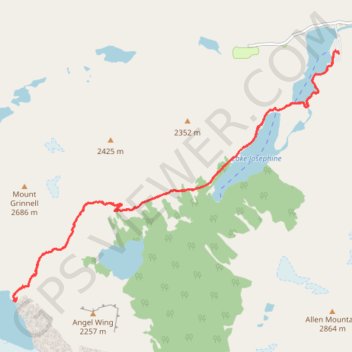
Grinnell Glacier Trail in Glacier National Park
The Grinnell Glacier Trail offers a breathtaking adventure filled with stunning alpine scenery. As you hike, you'll be treated to vibrant wildflower meadows, towering peaks like Mt. Grinnell and Angel Wing, and turquoise lakes, including Grinnell Lake and Lake Josephine. Along the way, you might spot wildlife like bighorn sheep, mountain goats, and even the occasional bear, adding to the thrill. The final ascent rewards you with magnificent views of Grinnell Glacier and Upper Grinnell Lake, making this hike an unforgettable experience. #Hiking #Mountain #Lake #Waterfall #Glacier #Nature #Forest
- Distance: 18.3 Km
- Elevation gain: 827 m
- Maximum elevation: 1,988 m
- Elevation loss: 827 m
- Minimum elevation: 1,487 m
- Moving time: 4 h 42 m
- Moving speed: 3.9 Km/h
- Maximum speed: 8.9 Km/h
- Total time: 6 h 1 m
- Global speed: 3.0 Km/h
Interactive trail map
Trail profile
- Distance: 18.3 Km
- Elevation gain: 827 m
- Maximum elevation: 1,988 m
- Elevation loss: 827 m
- Minimum elevation: 1,487 m
- Moving time: 4 h 42 m
- Moving speed: 3.9 Km/h
- Maximum speed: 8.9 Km/h
- Total time: 6 h 1 m
- Global speed: 3.0 Km/h
About this trail
Name: Grinnell Glacier Trail in Glacier National Park trail, distance, elevation, map, profile, GPS track
Start: Many Glacier Hotel Parking Road, Glacier County, Montana, United States (48.79644 -113.65606)
End: Many Glacier Hotel Parking Road, Glacier County, Montana, United States (48.79656 -113.65608)
Coordinates: 48.75953 -113.72946 48.79672 -113.65605
Other hiking, mountain biking, running and outdoor activity trails
Click on a trail to view its statistics, map and profile.
Highline Trail in Glacier National Park
United States > Montana > Glacier County
The Highline Trail is an enchanting journey that showcases the breathtaking beauty of nature! As you traverse the trail, you'll be treated to stunning panoramic views of towering peaks like Mount Reynolds and the Garden Wall, vibrant wildflowers, and perhaps even a glimpse of playful mountain goats or chirping…
Distance: 25.2 Km • Elevation gain: 1,263 m • Maximum elevation: 2,221 m
Highline Trail and Granite Park Trail in Glacier National Park
United States > Montana > Glacier County
The Highline Trail in Glacier National Park is a premier hiking route known for its stunning vistas along the Garden Wall, offering sweeping views of rugged peaks and deep valleys. Wildlife such as mountain goats and marmots often make appearances, adding to the trail’s allure. The Granite Park Chalet serves…
Distance: 19.2 Km • Elevation gain: 657 m • Maximum elevation: 2,225 m
Highline Trail to Great Northern Railway Buildings in Glacier National Park
United States > Montana > Flathead County
The Highline Trail in Glacier National Park offers hikers a dramatic and scenic route through wildflower-filled meadows, rugged cliffs, and alpine vistas. Along the way, you’ll encounter the famous Ledge Section and the iconic Garden Wall, where the trail hugs the cliffside above the Going-to-the-Sun Road,…
Distance: 24.4 Km • Elevation gain: 1,232 m • Maximum elevation: 2,226 m