Thank you for supporting this site ❤️
Make a donation
Make a donation
Gear up for your next adventure:
As an Amazon Associate, this site earns from qualifying purchases at no extra cost to you.
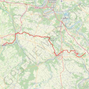
GR®26 De Douains à Bernay (Eure) (2023©gr-infos.com)
- Distance: 111.5 Km
- Elevation gain: 1,172 m
- Maximum elevation: 158 m
- Elevation loss: 1,194 m
- Minimum elevation: 33 m
Interactive trail map
Thank you for supporting this site ❤️
Make a donation
Make a donation
Gear up for your next adventure:
As an Amazon Associate, this site earns from qualifying purchases at no extra cost to you.
Trail profile
- Distance: 111.5 Km
- Elevation gain: 1,172 m
- Maximum elevation: 158 m
- Elevation loss: 1,194 m
- Minimum elevation: 33 m
Thank you for supporting this site ❤️
Make a donation
Make a donation
Gear up for your next adventure:
As an Amazon Associate, this site earns from qualifying purchases at no extra cost to you.
About this trail
Name: GR®26 De Douains à Bernay (Eure) (2023©gr-infos.com) trail, distance, elevation, map, profile, GPS track
Coordinates: 49.01153 0.59258 49.17893 1.42979
Thank you for supporting this site ❤️
Make a donation
Make a donation
Gear up for your next adventure:
As an Amazon Associate, this site earns from qualifying purchases at no extra cost to you.