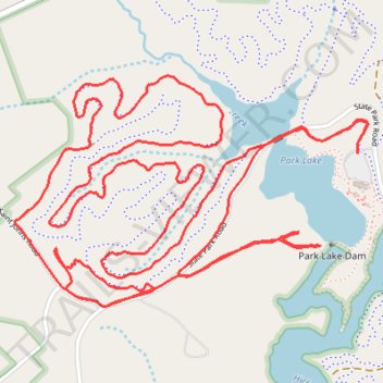
Lake Norman State Park Trail Run
- Distance: 10.6 Km
- Elevation gain: 142 m
- Maximum elevation: 272 m
- Elevation loss: 141 m
- Minimum elevation: 237 m
- Moving time: 1 h 23 m
- Moving speed: 7.6 Km/h
- Maximum speed: 17.4 Km/h
- Total time: 1 h 25 m
- Global speed: 7.5 Km/h
Interactive trail map
Trail profile
- Distance: 10.6 Km
- Elevation gain: 142 m
- Maximum elevation: 272 m
- Elevation loss: 141 m
- Minimum elevation: 237 m
- Moving time: 1 h 23 m
- Moving speed: 7.6 Km/h
- Maximum speed: 17.4 Km/h
- Total time: 1 h 25 m
- Global speed: 7.5 Km/h
About this trail
Name: Lake Norman State Park Trail Run trail, distance, elevation, map, profile, GPS track
Start: Alder Trail, Iredell County, North Carolina, United States (35.67362 -80.93268)
End: Alder Trail, Iredell County, North Carolina, United States (35.67377 -80.93268)
Coordinates: 35.66807 -80.94799 35.67645 -80.93219
Other hiking, mountain biking, running and outdoor activity trails
Click on a trail to view its statistics, map and profile.
Laurel Loop and Fallstown Loop in Lake Norman State Park
United States > North Carolina > Iredell County
Distance: 12.3 Km • Elevation gain: 121 m • Maximum elevation: 265 m
Lake Norman State Park
United States > North Carolina > Iredell County
Statesville Trail Run
Distance: 7.2 Km • Elevation gain: 84 m • Maximum elevation: 265 m
Lake Norman State Park
United States > North Carolina > Iredell County
Laurel Loop, Alder Trail and Hawk Loop
Distance: 12.5 Km • Elevation gain: 148 m • Maximum elevation: 261 m