Thank you for supporting this site ❤️
Make a donation
Make a donation
Gear up for your next adventure:
As an Amazon Associate, this site earns from qualifying purchases at no extra cost to you.
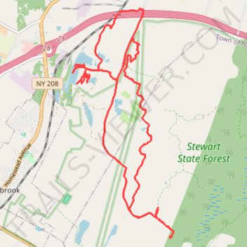
Stewart State Forest and Maybrook Reservoir
- Distance: 20.2 Km
- Elevation gain: 177 m
- Maximum elevation: 152 m
- Elevation loss: 177 m
- Minimum elevation: 111 m
- Moving time: 3 h 14 m
- Moving speed: 6.2 Km/h
- Maximum speed: 34.1 Km/h
- Total time: 6 h 28 m
- Global speed: 3.1 Km/h
Interactive trail map
Thank you for supporting this site ❤️
Make a donation
Make a donation
Gear up for your next adventure:
As an Amazon Associate, this site earns from qualifying purchases at no extra cost to you.
Trail profile
- Distance: 20.2 Km
- Elevation gain: 177 m
- Maximum elevation: 152 m
- Elevation loss: 177 m
- Minimum elevation: 111 m
- Moving time: 3 h 14 m
- Moving speed: 6.2 Km/h
- Maximum speed: 34.1 Km/h
- Total time: 6 h 28 m
- Global speed: 3.1 Km/h
Thank you for supporting this site ❤️
Make a donation
Make a donation
Gear up for your next adventure:
As an Amazon Associate, this site earns from qualifying purchases at no extra cost to you.
About this trail
Name: Stewart State Forest and Maybrook Reservoir trail, distance, elevation, map, profile, GPS track
Coordinates: 41.47480 -74.19951 41.51848 -74.17390
Thank you for supporting this site ❤️
Make a donation
Make a donation
Gear up for your next adventure:
As an Amazon Associate, this site earns from qualifying purchases at no extra cost to you.