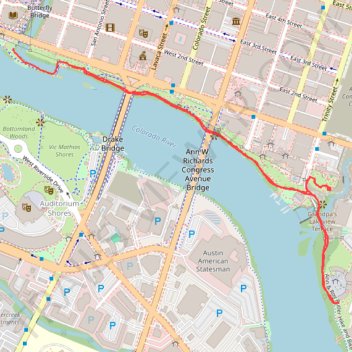
Northern shore of Butler Trail in Austin
- Distance: 3.3 Km
- Elevation gain: 28 m
- Maximum elevation: 146 m
- Elevation loss: 30 m
- Minimum elevation: 133 m
- Moving time: 34 m 57 s
- Moving speed: 5.7 Km/h
- Maximum speed: 9.3 Km/h
- Total time: 34 m 57 s
- Global speed: 5.7 Km/h
Interactive trail map
Trail profile
- Distance: 3.3 Km
- Elevation gain: 28 m
- Maximum elevation: 146 m
- Elevation loss: 30 m
- Minimum elevation: 133 m
- Moving time: 34 m 57 s
- Moving speed: 5.7 Km/h
- Maximum speed: 9.3 Km/h
- Total time: 34 m 57 s
- Global speed: 5.7 Km/h
About this trail
Name: Northern shore of Butler Trail in Austin trail, distance, elevation, map, profile, GPS track
End: Shoal Creek Trail, Seaholm, Austin, Travis County, Texas, 78701, United States (30.26502 -97.75169)
Coordinates: 30.25737 -97.75169 30.26502 -97.74038
Other hiking, mountain biking, running and outdoor activity trails
Click on a trail to view its statistics, map and profile.
Ann & Roy Butler Hike and Bike Trail in Austin
United States > Texas > Travis County > Austin
The Ann and Roy Butler Trail is a fantastic escape right in the heart of Austin, perfect for leisurely strolls or invigorating runs. With beautiful views of Lady Bird Lake, Colorado River and the Austin skyline, it’s a great spot to enjoy nature while still being close to the city buzz. Plus, there are…
Distance: 16.2 Km • Elevation gain: 118 m • Maximum elevation: 146 m
Butler Trail south shore boardwalk and Wishbone Bridge
United States > Texas > Travis County > Austin
Distance: 11.5 Km • Elevation gain: 87 m • Maximum elevation: 149 m
Central portion of the Ann & Roy Butler Trail including the Pfluger Bridge and South 1st Street Bridge
United States > Texas > Travis County > Austin
Distance: 3.0 Km • Elevation gain: 32 m • Maximum elevation: 144 m
Western portion of the Ann & Roy Butler Trail including the Pfluger Bridge
United States > Texas > Travis County > Austin
Distance: 5.9 Km • Elevation gain: 52 m • Maximum elevation: 146 m
Bike ride, fresh trail to Manor
United States > Texas > Travis County > Austin
Crowdstruck
Distance: 60.3 Km • Elevation gain: 396 m • Maximum elevation: 207 m