Import a GPX file

Pushawalla Palms and Hidden Palms Loop

Loop hike to Pushawalla Palms and Hidden Palms in the Coachella Valley Preserve. #Hiking #Loop #Nature #Desert

  • Distance: 7.8 Km
  • Elevation gain: 221 m
  • Maximum elevation: 252 m
  • Elevation loss: 221 m
  • Minimum elevation: 113 m

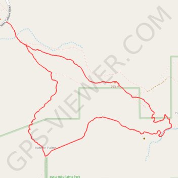
Interactive trail map

Trail profile

  • Distance: 7.8 Km
  • Elevation gain: 221 m
  • Maximum elevation: 252 m
  • Elevation loss: 221 m
  • Minimum elevation: 113 m

About this trail

Other hiking, mountain biking, running and outdoor activity trails

Click on a trail to view its statistics, map and profile.

Pushawalla Palms Loop

United States > California > Riverside County

Loop hike from Indian Palms Trailhead to Pushawalla Palms in the Indio Hills Palms Park. #Hiking #Loop #Nature #Desert #Forest #Park

Distance: 7.7 Km • Elevation gain: 226 m • Maximum elevation: 251 m

Gear up for your next adventure:

🔦LED Flashlight - Powerful and long-lasting flashlight for camping and emergencies
🧴Bear Spray Holster - Quick-access carry for essential Canadian wilderness safety
🔭Outdoor Binoculars - Lightweight binoculars for birdwatching and hiking
🥾Mountain Hiking Shoes - Shoes with superior grip for mountainous terrain
🥾Lightweight Hiking Shoes - Comfortable shoes for day hikes

As an Amazon Associate, this site earns from qualifying purchases at no extra cost to you.