
South Suburban Reservoir Loop via Ponderosa in Stratton Open Space
From Stratton Forest Heights, the route joins Cresta Trail and Ponderosa Trail through Stratton Open Space’s foothill scrub and scattered pines.
It follows Ponderosa past Arroyo Grande to Ridge Trail, reaching the South Suburban Reservoir area.
The walk then rounds the reservoir setting before returning north through the same quiet, neighborhood-edge open space.
#Hiking #Loop #Reservoir #Nature #Foothills #Walking
- Distance: 4.4 Km
- Elevation gain: 87 m
- Maximum elevation: 1,988 m
- Elevation loss: 85 m
- Minimum elevation: 1,936 m
- Moving time: 52 m 2 s
- Moving speed: 5.1 Km/h
- Maximum speed: 7.4 Km/h
- Total time: 56 m 57 s
- Global speed: 4.6 Km/h
Interactive trail map
Trail profile
- Distance: 4.4 Km
- Elevation gain: 87 m
- Maximum elevation: 1,988 m
- Elevation loss: 85 m
- Minimum elevation: 1,936 m
- Moving time: 52 m 2 s
- Moving speed: 5.1 Km/h
- Maximum speed: 7.4 Km/h
- Total time: 56 m 57 s
- Global speed: 4.6 Km/h
About this trail
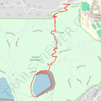
Name: South Suburban Reservoir Loop via Ponderosa in Stratton Open Space trail, distance, elevation, map, profile, GPS track
Coordinates: 38.79410 -104.86706 38.80451 -104.86142