Make a donation
Gear up for your next adventure:
As an Amazon Associate, this site earns from qualifying purchases at no extra cost to you.
Moonlight Challenge
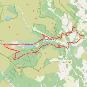
- Distance: 26.0 Km
- Elevation gain: 975 m
- Maximum elevation: 506 m
- Elevation loss: 974 m
- Minimum elevation: 126 m
- Moving time: 5 h 49 m
- Moving speed: 4.5 Km/h
- Maximum speed: 7.4 Km/h
- Total time: 6 h 41 m
- Global speed: 3.9 Km/h
Interactive trail map
Make a donation
Gear up for your next adventure:
As an Amazon Associate, this site earns from qualifying purchases at no extra cost to you.
Trail profile
- Distance: 26.0 Km
- Elevation gain: 975 m
- Maximum elevation: 506 m
- Elevation loss: 974 m
- Minimum elevation: 126 m
- Moving time: 5 h 49 m
- Moving speed: 4.5 Km/h
- Maximum speed: 7.4 Km/h
- Total time: 6 h 41 m
- Global speed: 3.9 Km/h
Make a donation
Gear up for your next adventure:
As an Amazon Associate, this site earns from qualifying purchases at no extra cost to you.
About this trail
Name: Moonlight Challenge trail, distance, elevation, map, profile, GPS track
Coordinates: 52.99258 -6.39830 53.02223 -6.27549
Make a donation
Gear up for your next adventure:
As an Amazon Associate, this site earns from qualifying purchases at no extra cost to you.
Other hiking, mountain biking, running and outdoor activity trails
Click on a trail to view its statistics, map and profile.
The Glendalough Hike - Wicklow Mountains National Park
Ireland > County Wicklow > Bookey Bridge
Distance: 18.9 Km • Elevation gain: 636 m • Maximum elevation: 503 m
Derrybawn Mountain Loop
Distance: 12.8 Km • Elevation gain: 448 m • Maximum elevation: 466 m
Glenealo Valley
Distance: 25.8 Km • Elevation gain: 937 m • Maximum elevation: 504 m