Thank you for supporting this site ❤️
Make a donation
Make a donation
Gear up for your next adventure:
As an Amazon Associate, this site earns from qualifying purchases at no extra cost to you.
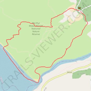
Hiking trail through Merthyr Mawr Sand dunes
Pen-Y-Bont Ar Ogwr Walking
- Distance: 5.5 Km
- Elevation gain: 83 m
- Maximum elevation: 71 m
- Elevation loss: 85 m
- Minimum elevation: 0 m
- Moving time: 1 h 49 m
- Moving speed: 3.0 Km/h
- Maximum speed: 4.7 Km/h
- Total time: 2 h 7 m
- Global speed: 2.6 Km/h
Interactive trail map
Thank you for supporting this site ❤️
Make a donation
Make a donation
Gear up for your next adventure:
As an Amazon Associate, this site earns from qualifying purchases at no extra cost to you.
Trail profile
- Distance: 5.5 Km
- Elevation gain: 83 m
- Maximum elevation: 71 m
- Elevation loss: 85 m
- Minimum elevation: 0 m
- Moving time: 1 h 49 m
- Moving speed: 3.0 Km/h
- Maximum speed: 4.7 Km/h
- Total time: 2 h 7 m
- Global speed: 2.6 Km/h
Thank you for supporting this site ❤️
Make a donation
Make a donation
Gear up for your next adventure:
As an Amazon Associate, this site earns from qualifying purchases at no extra cost to you.
About this trail
Name: Hiking trail through Merthyr Mawr Sand dunes trail, distance, elevation, map, profile, GPS track
Coordinates: 51.47000 -3.64775 51.48285 -3.62443
Thank you for supporting this site ❤️
Make a donation
Make a donation
Gear up for your next adventure:
As an Amazon Associate, this site earns from qualifying purchases at no extra cost to you.