Linley Valley Park
Vancouver Island. #Hiking #Running #Loop #LinleyValley #Vancouver
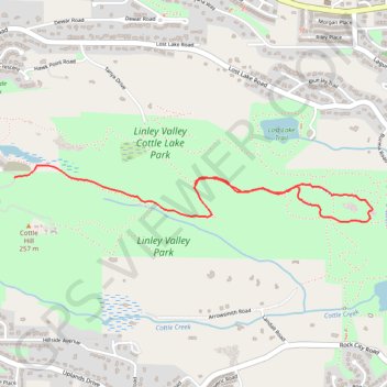
- Distance: 4.4 Km
- Elevation gain: 113 m
- Maximum elevation: 184 m
- Elevation loss: 113 m
- Minimum elevation: 115 m
Interactive trail map
Trail profile
- Distance: 4.4 Km
- Elevation gain: 113 m
- Maximum elevation: 184 m
- Elevation loss: 113 m
- Minimum elevation: 115 m
About this trail
Name: Linley Valley Park trail, distance, elevation, map, profile, GPS track
Coordinates: 49.22219 -124.00532 49.22458 -123.98213
Topography: Nanaimo topographic map, elevation, terrain
Other hiking, mountain biking, running and outdoor activity trails
Click on a trail to view its statistics, map and profile.
Linley Valley Park - Lost Lake - Cottle Lake
Canada > British Columbia > Regional District of Nanaimo > Nanaimo
Vancouver Island. #Hiking #Running #Loop #LinleyValley #Vancouver
Distance: 11.1 Km • Elevation gain: 260 m • Maximum elevation: 219 m
Linley Valley Cottle Lake Park
Canada > British Columbia > Regional District of Nanaimo > Nanaimo
Vancouver Island. #Hiking #Loop #LinleyValley #CottleLake #Vancouver
Distance: 9.7 Km • Elevation gain: 210 m • Maximum elevation: 184 m