Barak, Kippa and Vardit
ברק, ורדית וכיפה: שני קניונים משוגעים ותצפית על עמק עשוש בעומק הערבה
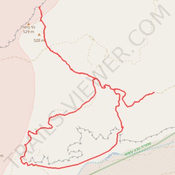
- Distance: 30.4 Km
- Elevation gain: 796 m
- Maximum elevation: 509 m
- Elevation loss: 796 m
- Minimum elevation: 160 m
- Moving time: 8 h 26 m
- Moving speed: 3.6 Km/h
- Maximum speed: 4.2 Km/h
- Total time: 8 h 26 m
- Global speed: 3.6 Km/h
Interactive trail map
Trail profile
- Distance: 30.4 Km
- Elevation gain: 796 m
- Maximum elevation: 509 m
- Elevation loss: 796 m
- Minimum elevation: 160 m
- Moving time: 8 h 26 m
- Moving speed: 3.6 Km/h
- Maximum speed: 4.2 Km/h
- Total time: 8 h 26 m
- Global speed: 3.6 Km/h
About this trail
Name: Barak, Kippa and Vardit trail, distance, elevation, map, profile, GPS track
Coordinates: 30.34684 35.02095 30.40993 35.08145