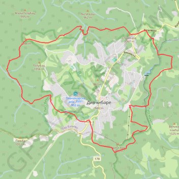
Divča BLUE Race 2023
- Distance: 13.5 Km
- Elevation gain: 770 m
- Maximum elevation: 1,067 m
- Elevation loss: 770 m
- Minimum elevation: 740 m
Interactive trail map
Trail profile
- Distance: 13.5 Km
- Elevation gain: 770 m
- Maximum elevation: 1,067 m
- Elevation loss: 770 m
- Minimum elevation: 740 m
About this trail
Name: Divča BLUE Race 2023 trail, distance, elevation, map, profile, GPS track
Coordinates: 44.09415 19.96491 44.12047 20.01292
Other hiking, mountain biking, running and outdoor activity trails
Click on a trail to view its statistics, map and profile.
2022_Yu
Slovenia > Ajdovščina > Žapuže
Distance: 2,457.3 Km • Elevation gain: 32,048 m • Maximum elevation: 1,950 m