Thank you for supporting this site ❤️
Make a donation
Make a donation
Gear up for your next adventure:
As an Amazon Associate, this site earns from qualifying purchases at no extra cost to you.
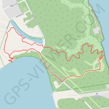
Long Pond and Happy Marsh loop trail in Widewater State Park
- Distance: 4.2 Km
- Elevation gain: 40 m
- Maximum elevation: 11 m
- Elevation loss: 40 m
- Minimum elevation: -1 m
- Moving time: 1 h 31 m
- Moving speed: 2.8 Km/h
- Maximum speed: 3.8 Km/h
- Total time: 1 h 54 m
- Global speed: 2.2 Km/h
Interactive trail map
Thank you for supporting this site ❤️
Make a donation
Make a donation
Gear up for your next adventure:
As an Amazon Associate, this site earns from qualifying purchases at no extra cost to you.
Trail profile
- Distance: 4.2 Km
- Elevation gain: 40 m
- Maximum elevation: 11 m
- Elevation loss: 40 m
- Minimum elevation: -1 m
- Moving time: 1 h 31 m
- Moving speed: 2.8 Km/h
- Maximum speed: 3.8 Km/h
- Total time: 1 h 54 m
- Global speed: 2.2 Km/h
Thank you for supporting this site ❤️
Make a donation
Make a donation
Gear up for your next adventure:
As an Amazon Associate, this site earns from qualifying purchases at no extra cost to you.
About this trail
Name: Long Pond and Happy Marsh loop trail in Widewater State Park trail, distance, elevation, map, profile, GPS track
Coordinates: 38.40502 -77.32824 38.41056 -77.31502
Thank you for supporting this site ❤️
Make a donation
Make a donation
Gear up for your next adventure:
As an Amazon Associate, this site earns from qualifying purchases at no extra cost to you.