Thank you for supporting this site ❤️
Make a donation
Make a donation
Gear up for your next adventure:
As an Amazon Associate, this site earns from qualifying purchases at no extra cost to you.
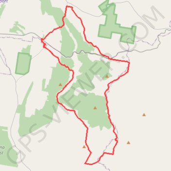
Cookamidgera - House of Commons Mountain loop
- Distance: 64.2 Km
- Elevation gain: 703 m
- Maximum elevation: 532 m
- Elevation loss: 703 m
- Minimum elevation: 300 m
- Moving time: 3 h 26 m
- Moving speed: 18.7 Km/h
- Maximum speed: 33.9 Km/h
- Total time: 3 h 26 m
- Global speed: 18.7 Km/h
Interactive trail map
Thank you for supporting this site ❤️
Make a donation
Make a donation
Gear up for your next adventure:
As an Amazon Associate, this site earns from qualifying purchases at no extra cost to you.
Trail profile
- Distance: 64.2 Km
- Elevation gain: 703 m
- Maximum elevation: 532 m
- Elevation loss: 703 m
- Minimum elevation: 300 m
- Moving time: 3 h 26 m
- Moving speed: 18.7 Km/h
- Maximum speed: 33.9 Km/h
- Total time: 3 h 26 m
- Global speed: 18.7 Km/h
Thank you for supporting this site ❤️
Make a donation
Make a donation
Gear up for your next adventure:
As an Amazon Associate, this site earns from qualifying purchases at no extra cost to you.
About this trail
Name: Cookamidgera - House of Commons Mountain loop trail, distance, elevation, map, profile, GPS track
Coordinates: -33.35857 148.30051 -33.16009 148.43247
Thank you for supporting this site ❤️
Make a donation
Make a donation
Gear up for your next adventure:
As an Amazon Associate, this site earns from qualifying purchases at no extra cost to you.
Other hiking, mountain biking, running and outdoor activity trails
Click on a trail to view its statistics, map and profile.
Eugowra - House of Commons Mountain loop
Australia > New South Wales > Eugowra
Distance: 65.5 Km • Elevation gain: 754 m • Maximum elevation: 524 m