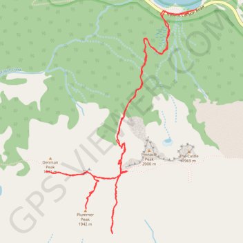
Hike to Plummer Peak and Denman Peak via Pinnacle Peak Trail and Pinnacle Saddle in the Mount Rainier National Park
- Distance: 8.2 Km
- Elevation gain: 568 m
- Maximum elevation: 1,892 m
- Elevation loss: 570 m
- Minimum elevation: 1,481 m
- Moving time: 3 h 12 m
- Moving speed: 2.6 Km/h
- Maximum speed: 10.8 Km/h
- Total time: 5 h 49 m
- Global speed: 1.4 Km/h
Interactive trail map
Trail profile
- Distance: 8.2 Km
- Elevation gain: 568 m
- Maximum elevation: 1,892 m
- Elevation loss: 570 m
- Minimum elevation: 1,481 m
- Moving time: 3 h 12 m
- Moving speed: 2.6 Km/h
- Maximum speed: 10.8 Km/h
- Total time: 5 h 49 m
- Global speed: 1.4 Km/h
About this trail
Name: Hike to Plummer Peak and Denman Peak via Pinnacle Peak Trail and Pinnacle Saddle in the Mount Rainier National Park trail, distance, elevation, map, profile, GPS track
Start: Stevens Canyon Road, Lewis County, Washington, United States (46.76819 -121.72827)
End: Stevens Canyon Road, Lewis County, Washington, United States (46.76831 -121.72823)
Coordinates: 46.75168 -121.74384 46.76848 -121.72738
Other hiking, mountain biking, running and outdoor activity trails
Click on a trail to view its statistics, map and profile.
Faraway Rock Loop via Mazama Ridge Trail in Mount Rainier National Park
United States > Washington > Pierce County > Paradise
The Faraway Rock Loop via Mazama Ridge Trail offers a peaceful yet rewarding hike through Mount Rainier National Park, where hikers are treated to expansive views of the surrounding wilderness. The route meanders through vibrant wildflower meadows in the summer, with stunning sights of Mount Rainier, the…
Distance: 8.4 Km • Elevation gain: 412 m • Maximum elevation: 1,763 m
Northern part of the Pacific Crest Trail (PCT)
United States > Oregon > Klamath County
Hike on the Pacific Crest National Scenic Trail from Crater Lake to Canada Border through Oregon and Washington along the Sierra Nevada and Cascade mountain ranges. #Hiking #Mountain #SierraNevada #Cascade #Nature #Forest #Park #PCT
Distance: 1,198.3 Km • Elevation gain: 44,308 m • Maximum elevation: 2,307 m
Plummer Peak via Pinnacle Peak Trail
United States > Washington > Lewis County
Distance: 8.4 Km • Elevation gain: 577 m • Maximum elevation: 1,894 m
New Track 9/24/22 6:13:29 AM
United States > Washington > Lewis County
Distance: 7.6 Km • Elevation gain: 754 m • Maximum elevation: 1,958 m