Munro Hillwalk An Teallach
Munro, Hillwalk, An, Teallach, Fiona, Thuill
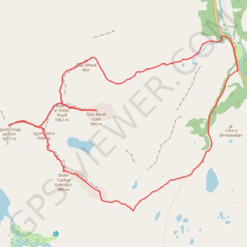
- Distance: 22.4 Km
- Elevation gain: 1,751 m
- Maximum elevation: 1,041 m
- Elevation loss: 1,749 m
- Minimum elevation: 35 m
- Moving time: 8 h 58 m
- Moving speed: 2.5 Km/h
- Maximum speed: 41.9 Km/h
- Total time: 11 h 38 m
- Global speed: 1.9 Km/h
Interactive trail map
Trail profile
- Distance: 22.4 Km
- Elevation gain: 1,751 m
- Maximum elevation: 1,041 m
- Elevation loss: 1,749 m
- Minimum elevation: 35 m
- Moving time: 8 h 58 m
- Moving speed: 2.5 Km/h
- Maximum speed: 41.9 Km/h
- Total time: 11 h 38 m
- Global speed: 1.9 Km/h
About this trail
Name: Munro Hillwalk An Teallach trail, distance, elevation, map, profile, GPS track
Start: A832, Dundonnell House, Highland, Scotland, IV23 2QN, United Kingdom (57.81524 -5.17601)
End: A832, Highland, Scotland, IV23 2QN, United Kingdom (57.81436 -5.17580)
Coordinates: 57.78189 -5.27416 57.82203 -5.17580