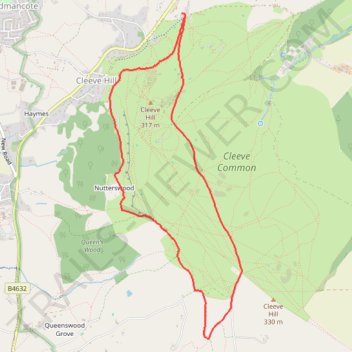
Cleeve Common Loop Walk
- Distance: 7.2 Km
- Elevation gain: 191 m
- Maximum elevation: 326 m
- Elevation loss: 193 m
- Minimum elevation: 230 m
- Moving time: 2 h 12 m
- Moving speed: 3.3 Km/h
- Maximum speed: 6.0 Km/h
- Total time: 2 h 27 m
- Global speed: 2.9 Km/h
Interactive trail map
Trail profile
- Distance: 7.2 Km
- Elevation gain: 191 m
- Maximum elevation: 326 m
- Elevation loss: 193 m
- Minimum elevation: 230 m
- Moving time: 2 h 12 m
- Moving speed: 3.3 Km/h
- Maximum speed: 6.0 Km/h
- Total time: 2 h 27 m
- Global speed: 2.9 Km/h
About this trail
Name: Cleeve Common Loop Walk trail, distance, elevation, map, profile, GPS track
Coordinates: 51.91660 -2.02755 51.94327 -2.00994
Other hiking, mountain biking, running and outdoor activity trails
Click on a trail to view its statistics, map and profile.
Winchcombe Cheltenham loop trailrun
United Kingdom > England > Gloucestershire > Winchcombe
Distance: 26.2 Km • Elevation gain: 594 m • Maximum elevation: 327 m
Dean2023-311
United Kingdom > England > Oxfordshire > Oxford
Distance: 310.3 Km • Elevation gain: 3,366 m • Maximum elevation: 290 m