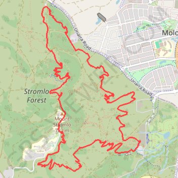
Stromlo Forest Loop
Interactive trail map
Trail profile
- Distance: 14.1 Km
- Elevation gain: 330 m
- Maximum elevation: 779 m
- Elevation loss: 330 m
- Minimum elevation: 591 m
About this trail
Name: Stromlo Forest Loop trail, distance, elevation, map, profile, GPS track
Start: Wattle Happen, Canberra, Australian Capital Territory, Australia (-35.32018 149.02427)
End: Wattle Happen, Canberra, Australian Capital Territory, Australia (-35.32018 149.02427)
Coordinates: -35.32446 149.00614 -35.30071 149.02433
Other hiking, mountain biking, running and outdoor activity trails
Click on a trail to view its statistics, map and profile.
Cloudride24.FINAL
Distance: 1,028.8 Km • Elevation gain: 21,282 m • Maximum elevation: 1,754 m