Thank you for supporting this site ❤️
Make a donation
Make a donation
Gear up for your next adventure:
As an Amazon Associate, this site earns from qualifying purchases at no extra cost to you.
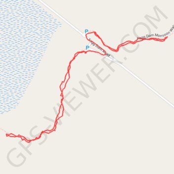
Fog Dam walks
- Distance: 2.0 Km
- Elevation gain: 7 m
- Maximum elevation: 12 m
- Elevation loss: 6 m
- Minimum elevation: 7 m
- Moving time: 43 m 11 s
- Moving speed: 2.8 Km/h
- Maximum speed: 15.8 Km/h
- Total time: 1 h 20 m
- Global speed: 1.5 Km/h
Interactive trail map
Thank you for supporting this site ❤️
Make a donation
Make a donation
Gear up for your next adventure:
As an Amazon Associate, this site earns from qualifying purchases at no extra cost to you.
Trail profile
- Distance: 2.0 Km
- Elevation gain: 7 m
- Maximum elevation: 12 m
- Elevation loss: 6 m
- Minimum elevation: 7 m
- Moving time: 43 m 11 s
- Moving speed: 2.8 Km/h
- Maximum speed: 15.8 Km/h
- Total time: 1 h 20 m
- Global speed: 1.5 Km/h
Thank you for supporting this site ❤️
Make a donation
Make a donation
Gear up for your next adventure:
As an Amazon Associate, this site earns from qualifying purchases at no extra cost to you.
About this trail
Name: Fog Dam walks trail, distance, elevation, map, profile, GPS track
Coordinates: -12.57033 131.30541 -12.56676 131.31073
Thank you for supporting this site ❤️
Make a donation
Make a donation
Gear up for your next adventure:
As an Amazon Associate, this site earns from qualifying purchases at no extra cost to you.
Other hiking, mountain biking, running and outdoor activity trails
Click on a trail to view its statistics, map and profile.
Fogg Dam Monsoon Walk
Australia > Litchfield Municipality > Middle Point
Distance: 2.0 Km • Elevation gain: 10 m • Maximum elevation: 19 m