Make a donation
Gear up for your next adventure:
As an Amazon Associate, this site earns from qualifying purchases at no extra cost to you.
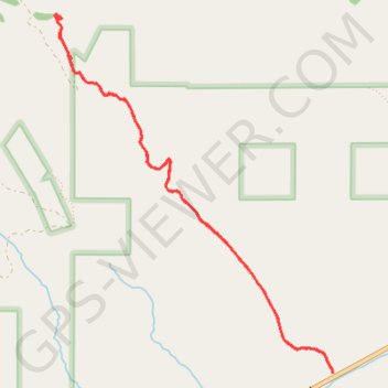
Adelmann Mine in Boise Front Area of Critical Environmental Concern
The Adelmann Mine trail offers a captivating hike through diverse landscapes, including forests and open meadows. As you approach the historic gold mine, you'll encounter remnants of mining operations along with scenic views of the surrounding mountains and Boise River, making it a rewarding experience for those interested in history and nature alike. #Hiking #Mountain #Forest #Nature
- Distance: 7.7 Km
- Elevation gain: 426 m
- Maximum elevation: 1,511 m
- Elevation loss: 426 m
- Minimum elevation: 1,106 m
- Moving time: 1 h 58 m
- Moving speed: 3.9 Km/h
- Maximum speed: 10.7 Km/h
- Total time: 2 h 11 m
- Global speed: 3.5 Km/h
Interactive trail map
Make a donation
Gear up for your next adventure:
As an Amazon Associate, this site earns from qualifying purchases at no extra cost to you.
Trail profile
- Distance: 7.7 Km
- Elevation gain: 426 m
- Maximum elevation: 1,511 m
- Elevation loss: 426 m
- Minimum elevation: 1,106 m
- Moving time: 1 h 58 m
- Moving speed: 3.9 Km/h
- Maximum speed: 10.7 Km/h
- Total time: 2 h 11 m
- Global speed: 3.5 Km/h
Make a donation
Gear up for your next adventure:
As an Amazon Associate, this site earns from qualifying purchases at no extra cost to you.
About this trail
Name: Adelmann Mine in Boise Front Area of Critical Environmental Concern trail, distance, elevation, map, profile, GPS track
Start: Adleman Mine Trail, Ada County, Idaho, United States (43.57428 -116.02202)
End: Adleman Mine Trail, Ada County, Idaho, United States (43.57414 -116.02199)
Coordinates: 43.57414 -116.04663 43.59720 -116.02197
Make a donation
Gear up for your next adventure:
As an Amazon Associate, this site earns from qualifying purchases at no extra cost to you.