Import a GPX file

Arrow Valley Country Park Loop

  • Distance: 5.0 Km
  • Elevation gain: 24 m
  • Maximum elevation: 86 m
  • Elevation loss: 25 m
  • Minimum elevation: 77 m
  • Moving time: 31 m 12 s
  • Moving speed: 9.6 Km/h
  • Maximum speed: 16.5 Km/h
  • Total time: 31 m 12 s
  • Global speed: 9.6 Km/h

Interactive trail map

Trail profile

  • Distance: 5.0 Km
  • Elevation gain: 24 m
  • Maximum elevation: 86 m
  • Elevation loss: 25 m
  • Minimum elevation: 77 m
  • Moving time: 31 m 12 s
  • Moving speed: 9.6 Km/h
  • Maximum speed: 16.5 Km/h
  • Total time: 31 m 12 s
  • Global speed: 9.6 Km/h

About this trail
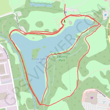
Name: Arrow Valley Country Park Loop trail, distance, elevation, map, profile, GPS track

Start: Proctors Barn Lane, Lakeside, Redditch, Worcestershire, England, B98 8YW, United Kingdom (52.30610 -1.91399)

End: Coventry Highway, Abbeydale, Redditch, Worcestershire, England, B98 8QE, United Kingdom (52.30795 -1.91018)

Coordinates: 52.30110 -1.91630 52.30795 -1.90628

Gear up for your next adventure:

🔋Emergency Crank Radio - Weather alerts and power without needing batteries
🧥Insulated Jacket - Keep warm in cold outdoor conditions
🎒Hiking Backpack - Lightweight and ergonomic backpacks for day hikes or multi-day treks
🔦UV Flashlight - Detect minerals or specific insects in the dark
❄️Traction Ice Cleats - Slip-on spikes for icy trails and winter hiking

As an Amazon Associate, this site earns from qualifying purchases at no extra cost to you.