Thank you for supporting this site ❤️
Make a donation
Make a donation
Gear up for your next adventure:
As an Amazon Associate, this site earns from qualifying purchases at no extra cost to you.
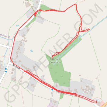
R SK400430
- Distance: 4.3 Km
- Elevation gain: 61 m
- Maximum elevation: 109 m
- Elevation loss: 56 m
- Minimum elevation: 87 m
- Moving time: 44 m 18 s
- Moving speed: 5.8 Km/h
- Maximum speed: 56.0 Km/h
- Total time: 1 h 25 m
- Global speed: 3.0 Km/h
Interactive trail map
Thank you for supporting this site ❤️
Make a donation
Make a donation
Gear up for your next adventure:
As an Amazon Associate, this site earns from qualifying purchases at no extra cost to you.
Trail profile
- Distance: 4.3 Km
- Elevation gain: 61 m
- Maximum elevation: 109 m
- Elevation loss: 56 m
- Minimum elevation: 87 m
- Moving time: 44 m 18 s
- Moving speed: 5.8 Km/h
- Maximum speed: 56.0 Km/h
- Total time: 1 h 25 m
- Global speed: 3.0 Km/h
Thank you for supporting this site ❤️
Make a donation
Make a donation
Gear up for your next adventure:
As an Amazon Associate, this site earns from qualifying purchases at no extra cost to you.
About this trail
Name: R SK400430 trail, distance, elevation, map, profile, GPS track
Coordinates: 52.98245 -1.41069 52.98856 -1.40186
Thank you for supporting this site ❤️
Make a donation
Make a donation
Gear up for your next adventure:
As an Amazon Associate, this site earns from qualifying purchases at no extra cost to you.