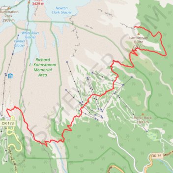
Timberline Trail #600 East and South
- Distance: 16.2 Km
- Elevation gain: 747 m
- Maximum elevation: 1,972 m
- Elevation loss: 921 m
- Minimum elevation: 1,489 m
- Moving time: 4 h 11 m
- Moving speed: 3.9 Km/h
- Maximum speed: 8.1 Km/h
- Total time: 5 h 52 m
- Global speed: 2.8 Km/h
Interactive trail map
Trail profile
- Distance: 16.2 Km
- Elevation gain: 747 m
- Maximum elevation: 1,972 m
- Elevation loss: 921 m
- Minimum elevation: 1,489 m
- Moving time: 4 h 11 m
- Moving speed: 3.9 Km/h
- Maximum speed: 8.1 Km/h
- Total time: 5 h 52 m
- Global speed: 2.8 Km/h
About this trail
Name: Timberline Trail #600 East and South trail, distance, elevation, map, profile, GPS track
Start: Timberline Trail #600, Hood River County, Oregon, United States (45.36124 -121.64913)
End: Gotta Get Back, Clackamas County, Oregon, 97028, United States (45.33058 -121.70943)
Coordinates: 45.32036 -121.71128 45.36154 -121.63324
Other hiking, mountain biking, running and outdoor activity trails
Click on a trail to view its statistics, map and profile.
Northern part of the Pacific Crest Trail (PCT)
United States > Oregon > Klamath County
Hike on the Pacific Crest National Scenic Trail from Crater Lake to Canada Border through Oregon and Washington along the Sierra Nevada and Cascade mountain ranges. #Hiking #Mountain #SierraNevada #Cascade #Nature #Forest #Park #PCT
Distance: 1,198.3 Km • Elevation gain: 44,308 m • Maximum elevation: 2,307 m
Pacific Crest National Scenic Trail (PCT) #2000
United States > Oregon > Clackamas County
Distance: 15.0 Km • Elevation gain: 362 m • Maximum elevation: 1,856 m
Timberline Trail #600 North and East
United States > Oregon > Hood River County
Distance: 19.6 Km • Elevation gain: 1,150 m • Maximum elevation: 2,233 m