Thank you for supporting this site ❤️
Make a donation
Make a donation
Gear up for your next adventure:
As an Amazon Associate, this site earns from qualifying purchases at no extra cost to you.
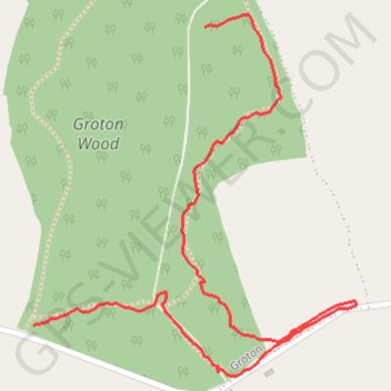
Groton Wood Nature Reserve
- Distance: 1.4 Km
- Elevation gain: 15 m
- Maximum elevation: 72 m
- Elevation loss: 11 m
- Minimum elevation: 64 m
- Moving time: 19 m 47 s
- Moving speed: 4.2 Km/h
- Maximum speed: 9.3 Km/h
- Total time: 19 m 47 s
- Global speed: 4.2 Km/h
Interactive trail map
Thank you for supporting this site ❤️
Make a donation
Make a donation
Gear up for your next adventure:
As an Amazon Associate, this site earns from qualifying purchases at no extra cost to you.
Trail profile
- Distance: 1.4 Km
- Elevation gain: 15 m
- Maximum elevation: 72 m
- Elevation loss: 11 m
- Minimum elevation: 64 m
- Moving time: 19 m 47 s
- Moving speed: 4.2 Km/h
- Maximum speed: 9.3 Km/h
- Total time: 19 m 47 s
- Global speed: 4.2 Km/h
Thank you for supporting this site ❤️
Make a donation
Make a donation
Gear up for your next adventure:
As an Amazon Associate, this site earns from qualifying purchases at no extra cost to you.
About this trail
Name: Groton Wood Nature Reserve trail, distance, elevation, map, profile, GPS track
Start: Bulmer Lane, Groton, Boxford, Babergh, Suffolk, England, CO10 5EZ, United Kingdom (52.05256 0.88411)
End: Bulmer Lane, Groton, Boxford, Babergh, Suffolk, England, CO10 5EZ, United Kingdom (52.04900 0.88079)
Coordinates: 52.04839 0.88079 52.05271 0.88706
Thank you for supporting this site ❤️
Make a donation
Make a donation
Gear up for your next adventure:
As an Amazon Associate, this site earns from qualifying purchases at no extra cost to you.