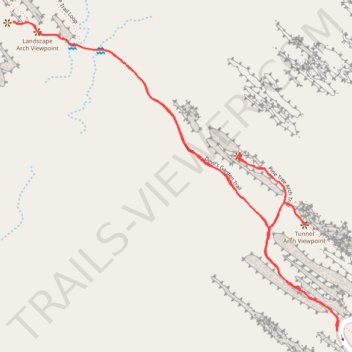
Pine Tree Arch, Tunnel Arch and Landscape Arch via Devil's Garden Trail
The Devil's Garden Trail in Arches National Park offers hikers a captivating journey through a landscape adorned with natural sandstone arches and unique rock formations. Along the path, you'll encounter Tunnel Arch, a distinctive opening through a rock fin; Pine Tree Arch, named for the pine trees growing beneath it; and the impressive Landscape Arch, one of the world's longest natural arches. The trail meanders through a variety of terrains, including towering fins, expansive vistas, and diverse plant life, providing a comprehensive experience of the park's geological and ecological wonders. #Hiking #Arch #Rock #Desert #Nature
- Distance: 3.9 Km
- Elevation gain: 114 m
- Maximum elevation: 1,608 m
- Elevation loss: 114 m
- Minimum elevation: 1,571 m
- Moving time: 1 h 53 s
- Moving speed: 3.9 Km/h
- Maximum speed: 6.0 Km/h
- Total time: 1 h 21 m
- Global speed: 2.9 Km/h
Interactive trail map
Trail profile
- Distance: 3.9 Km
- Elevation gain: 114 m
- Maximum elevation: 1,608 m
- Elevation loss: 114 m
- Minimum elevation: 1,571 m
- Moving time: 1 h 53 s
- Moving speed: 3.9 Km/h
- Maximum speed: 6.0 Km/h
- Total time: 1 h 21 m
- Global speed: 2.9 Km/h
About this trail
Name: Pine Tree Arch, Tunnel Arch and Landscape Arch via Devil's Garden Trail trail, distance, elevation, map, profile, GPS track
Start: Arches Main Road, Grand County, Utah, United States (38.78258 -109.59519)
End: Arches Main Road, Grand County, Utah, United States (38.78258 -109.59517)
Coordinates: 38.78258 -109.60673 38.79119 -109.59511
Other hiking, mountain biking, running and outdoor activity trails
Click on a trail to view its statistics, map and profile.
Landscape Arch Trail via Devil's Garden Trail in Arches National Park
United States > Utah > Grand County
The Devil's Garden and Landscape Arch Trails offer hikers a journey through a diverse array of geological formations. Along the path, one can observe the narrow Tunnel Arch, the Pine Tree Arch, and the slender and expansive Landscape Arch — the longest in North America — each showcasing unique natural…
Distance: 3.0 Km • Elevation gain: 83 m • Maximum elevation: 1,607 m
Devil's Garden Trail in Arches National Park
United States > Utah > Grand County
The Devil's Garden Loop Trail winds through a breathtaking desert landscape, showcasing an array of stunning arches like the graceful Landscape Arch and the impressive Double O Arch. With its mix of well-maintained paths and challenging scrambles, this hike is perfect for adventurers seeking both beautiful…
Distance: 12.7 Km • Elevation gain: 370 m • Maximum elevation: 1,677 m
Devil's Garden Primitive Trail Loop in Arches National Park
United States > Utah > Grand County
The Devil's Garden Primitive Trail Loop in Arches National Park is a thrilling and visually stunning route for experienced hikers. Beginning with views of famous arches like Landscape Arch, the trail soon takes a challenging turn, leading hikers along narrow rock fins, past the remains of Wall Arch, and…
Distance: 12.3 Km • Elevation gain: 346 m • Maximum elevation: 1,678 m
Arches National Park Loop
United States > Utah > Grand County
Loop hike via Devil's Garden Trail, Pine Tree Arch Trail, Tunnel Arch Viewpoint, Pine Tree Arch Viewpoint, Devil's Garden Primitive Trail Loop, Private Arch Trail, Dark Angel Trail, Dark Viewpoint, Double O Arch Trail, Black Arch Overlook Trail, Navajo Arch Trail, Partition Arch Trail and Landscape Arch…
Distance: 13.6 Km • Elevation gain: 421 m • Maximum elevation: 1,681 m
Devil's Garden Trail
United States > Utah > Grand County
Loop hike in the Arches National Park via Devil's Garden Trail, Landscape Arch Viewpoint, Navajo Arch Trail, Partition Arch Trail, Black Arch Overlook, Double O Arch Trail, Private Arch Trail, Pine Tree Arch Trail and Pine Tree Arch Viewpoint. #Hiking #Loop #Nature #Rock #Park #Mountain #Overlook #Desert
Distance: 10.2 Km • Elevation gain: 308 m • Maximum elevation: 1,678 m