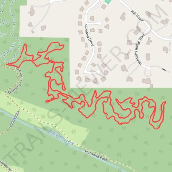
Allatoona Creek Park Wildcat Loop
- Distance: 4.6 Km
- Elevation gain: 85 m
- Maximum elevation: 284 m
- Elevation loss: 86 m
- Minimum elevation: 262 m
- Moving time: 1 h 4 m
- Moving speed: 4.3 Km/h
- Maximum speed: 7.0 Km/h
- Total time: 1 h 4 m
- Global speed: 4.3 Km/h
Interactive trail map
Trail profile
- Distance: 4.6 Km
- Elevation gain: 85 m
- Maximum elevation: 284 m
- Elevation loss: 86 m
- Minimum elevation: 262 m
- Moving time: 1 h 4 m
- Moving speed: 4.3 Km/h
- Maximum speed: 7.0 Km/h
- Total time: 1 h 4 m
- Global speed: 4.3 Km/h
About this trail
Name: Allatoona Creek Park Wildcat Loop trail, distance, elevation, map, profile, GPS track
Start: Driftwood, Hill Forest Estates, Cobb County, Georgia, 30101, United States (34.03290 -84.71570)
End: Driftwood, Hill Forest Estates, Cobb County, Georgia, 30101, United States (34.03288 -84.71575)
Coordinates: 34.03004 -84.71575 34.03384 -84.70736
Other hiking, mountain biking, running and outdoor activity trails
Click on a trail to view its statistics, map and profile.
Powder Springs, Allatoona trails, Dallas, Chatt Hills
United States > Georgia > Fayette County > Tyrone > Stop
Distance: 319.6 Km • Elevation gain: 3,805 m • Maximum elevation: 379 m
Allatoona Creek Gravel trails
United States > Georgia > Cobb County
Distance: 18.0 Km • Elevation gain: 122 m • Maximum elevation: 283 m