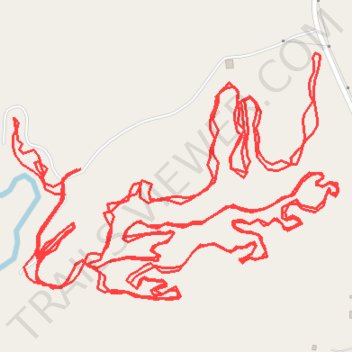
Brownsville Rockin' Roll Hatchie MTB Trails
- Distance: 10.8 Km
- Elevation gain: 81 m
- Maximum elevation: 113 m
- Elevation loss: 84 m
- Minimum elevation: 99 m
- Moving time: 1 h 2 m
- Moving speed: 10.4 Km/h
- Maximum speed: 26.1 Km/h
- Total time: 1 h 4 m
- Global speed: 10.0 Km/h
Interactive trail map
Trail profile
- Distance: 10.8 Km
- Elevation gain: 81 m
- Maximum elevation: 113 m
- Elevation loss: 84 m
- Minimum elevation: 99 m
- Moving time: 1 h 2 m
- Moving speed: 10.4 Km/h
- Maximum speed: 26.1 Km/h
- Total time: 1 h 4 m
- Global speed: 10.0 Km/h
About this trail
Name: Brownsville Rockin' Roll Hatchie MTB Trails trail, distance, elevation, map, profile, GPS track
Start: Haywood County, West Tennessee, Tennessee, United States (35.56284 -89.26542)
End: Haywood County, West Tennessee, Tennessee, United States (35.56088 -89.26501)
Coordinates: 35.56031 -89.26702 35.56511 -89.25926