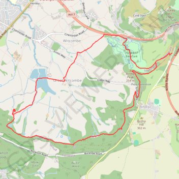
Witcombe Loop
Loop hike around Great Witcombe from Barrow Wake via Viner's Plantation, Birdlip Peak, Peak Plantation, Witcombe Wood, Great Witcombe Roman Villa, Witcombe Reservoirs and Flyup 417 Bike Park. #Hiking #Loop #Nature #Forest #Lake
- Distance: 11.1 Km
- Elevation gain: 339 m
- Maximum elevation: 275 m
- Elevation loss: 300 m
- Minimum elevation: 86 m
- Moving time: 2 h 28 m
- Moving speed: 4.5 Km/h
- Maximum speed: 17.6 Km/h
- Total time: 3 h 23 m
- Global speed: 3.3 Km/h
Interactive trail map
Trail profile
- Distance: 11.1 Km
- Elevation gain: 339 m
- Maximum elevation: 275 m
- Elevation loss: 300 m
- Minimum elevation: 86 m
- Moving time: 2 h 28 m
- Moving speed: 4.5 Km/h
- Maximum speed: 17.6 Km/h
- Total time: 3 h 23 m
- Global speed: 3.3 Km/h
About this trail
Name: Witcombe Loop trail, distance, elevation, map, profile, GPS track
Coordinates: 51.82077 -2.14995 51.84101 -2.10080
Other hiking, mountain biking, running and outdoor activity trails
Click on a trail to view its statistics, map and profile.
Painswick Witcombe
United Kingdom > England > Gloucestershire > Painswick > Ham Butts
Distance: 18.7 Km • Elevation gain: 529 m • Maximum elevation: 279 m
Birdlip Loop via Witcombe Reservoirs
United Kingdom > England > Gloucestershire > Tewkesbury > Great Witcombe
Distance: 8.0 Km • Elevation gain: 255 m • Maximum elevation: 292 m
Dean2023-311
United Kingdom > England > Oxfordshire > Oxford
Distance: 310.3 Km • Elevation gain: 3,366 m • Maximum elevation: 290 m