Thank you for supporting this site ❤️
Make a donation
Make a donation
Gear up for your next adventure:
As an Amazon Associate, this site earns from qualifying purchases at no extra cost to you.
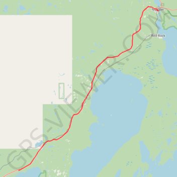
Shuniah - Nipigon
Lake Superior. #Bike #Shuniah #Nipigon #LakeSuperior
- Distance: 75.0 Km
- Elevation gain: 467 m
- Maximum elevation: 323 m
- Elevation loss: 518 m
- Minimum elevation: 183 m
Interactive trail map
Thank you for supporting this site ❤️
Make a donation
Make a donation
Gear up for your next adventure:
As an Amazon Associate, this site earns from qualifying purchases at no extra cost to you.
Trail profile
- Distance: 75.0 Km
- Elevation gain: 467 m
- Maximum elevation: 323 m
- Elevation loss: 518 m
- Minimum elevation: 183 m
Thank you for supporting this site ❤️
Make a donation
Make a donation
Gear up for your next adventure:
As an Amazon Associate, this site earns from qualifying purchases at no extra cost to you.
About this trail
Name: Shuniah - Nipigon trail, distance, elevation, map, profile, GPS track
Coordinates: 48.56350 -88.85195 49.02236 -88.25754
Topography: Shuniah topographic map, elevation, terrain
Thank you for supporting this site ❤️
Make a donation
Make a donation
Gear up for your next adventure:
As an Amazon Associate, this site earns from qualifying purchases at no extra cost to you.