The Priest via Crabtree Falls
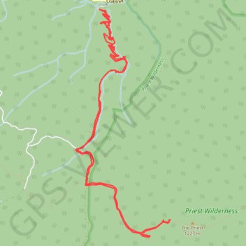
Starting at Crabtree Falls, the route climbs the switchbacking Crabtree Falls Trail beside Crabtree Creek, passing a succession of cascades, rock ledges, forested slopes and valley overlooks before reaching the quieter upper creek area near Crabtree Meadows.
It then continues through a more remote mountain corridor on Shoe Creek Trail, crossing wooded hollows and small streams before meeting the white-blazed Appalachian Trail and entering the rugged Priest Wilderness.
The final approach follows the Appalachian Trail through oak forest, laurel thickets and rocky ridge terrain, passes The Priest Shelter area, and finishes at The Priest with broad views toward Cox Creek Valley, Three Ridges, the Blue Ridge and the surrounding George Washington National Forest.
#Hiking #Mountain #Falls #Nature #Forest #River #Wilderness
- Distance: 15.3 Km
- Elevation gain: 900 m
- Maximum elevation: 1,223 m
- Elevation loss: 903 m
- Minimum elevation: 503 m
- Moving time: 4 h 1 m
- Moving speed: 3.8 Km/h
- Maximum speed: 6.6 Km/h
- Total time: 4 h 52 m
- Global speed: 3.1 Km/h
Interactive trail map
Trail profile
- Distance: 15.3 Km
- Elevation gain: 900 m
- Maximum elevation: 1,223 m
- Elevation loss: 903 m
- Minimum elevation: 503 m
- Moving time: 4 h 1 m
- Moving speed: 3.8 Km/h
- Maximum speed: 6.6 Km/h
- Total time: 4 h 52 m
- Global speed: 3.1 Km/h
About this trail
Name: The Priest via Crabtree Falls trail, distance, elevation, map, profile, GPS track
Start: Crabtree Falls Trail, Nelson County, Virginia, 24464, United States (37.85071 -79.07883)
End: Crabtree Falls Trail, Nelson County, Virginia, 24464, United States (37.85080 -79.07914)
Coordinates: 37.81782 -79.08390 37.85096 -79.06655