Millbrook Mountain Trail and Gertrude's Nose Trail Loop from Lake Minnewaska
The Millbrook Mountain and Gertrude’s Nose Trail Loop is a captivating hiking experience that showcases the rugged beauty of the Shawangunk Ridge. As you ascend, expect to be surrounded by ancient pitch pines and diverse flora, while the trail offers breathtaking panoramic views of the Hudson Valley and nearby highlands. The journey culminates at Gertrude's Nose, where stunning cliffside vistas reward your efforts, providing a perfect spot to pause and soak in the natural splendor. #Hiking #Loop #Mountain #Forest #Lake #Rock #Nature
- Distance: 11.3 Km
- Elevation gain: 306 m
- Maximum elevation: 546 m
- Elevation loss: 299 m
- Minimum elevation: 393 m
- Moving time: 3 h 28 m
- Moving speed: 3.3 Km/h
- Maximum speed: 8.1 Km/h
- Total time: 4 h 18 m
- Global speed: 2.6 Km/h
Interactive trail map
Trail profile
- Distance: 11.3 Km
- Elevation gain: 306 m
- Maximum elevation: 546 m
- Elevation loss: 299 m
- Minimum elevation: 393 m
- Moving time: 3 h 28 m
- Moving speed: 3.3 Km/h
- Maximum speed: 8.1 Km/h
- Total time: 4 h 18 m
- Global speed: 2.6 Km/h
About this trail
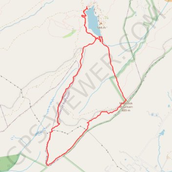
Name: Millbrook Mountain Trail and Gertrude's Nose Trail Loop from Lake Minnewaska trail, distance, elevation, map, profile, GPS track
End: Hamilton Point Trail, Town of Rochester, Ulster County, New York, United States (41.72863 -74.23726)
Coordinates: 41.69426 -74.24903 41.72863 -74.22595
Other hiking, mountain biking, running and outdoor activity trails
Click on a trail to view its statistics, map and profile.