Import a GPX file

Redwoods Grove

Hike to Redwoods Grove in the Carbon Canyon Regional Park. #Hiking #Forest #Nature #Canyon #Park

  • Distance: 1.0 Km
  • Elevation gain: 27 m
  • Maximum elevation: 149 m
  • Elevation loss: 13 m
  • Minimum elevation: 130 m

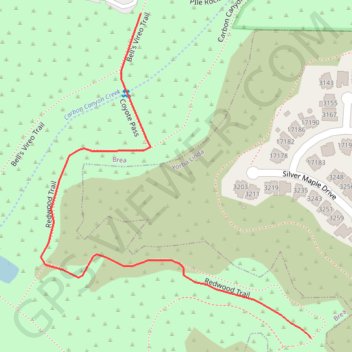
Interactive trail map

Trail profile

  • Distance: 1.0 Km
  • Elevation gain: 27 m
  • Maximum elevation: 149 m
  • Elevation loss: 13 m
  • Minimum elevation: 130 m

About this trail

Name: Redwoods Grove trail, distance, elevation, map, profile, GPS track

Start: Bell's Vireo Trail, Brea, Orange County, California, 92823, United States (33.91866 -117.83696)

End: Redwood Trail, Brea, Orange County, California, 92823, United States (33.91420 -117.83415)

Coordinates: 33.91420 -117.83861 33.91866 -117.83415

Gear up for your next adventure:

🚲MTB Frame Bag - Carry tools and maps directly on your bicycle frame
🥫Freeze-Dried Meals - Lightweight, high-calorie nutrition for multi-day treks
🔭Outdoor Binoculars - Lightweight binoculars for birdwatching and hiking
🚲Handlebar Phone Mount - View topographic-map.com live while cycling
🕯️Camping Lantern - Illuminates your entire campsite with high-efficiency LEDs

As an Amazon Associate, this site earns from qualifying purchases at no extra cost to you.