Make a donation
Gear up for your next adventure:
As an Amazon Associate, this site earns from qualifying purchases at no extra cost to you.
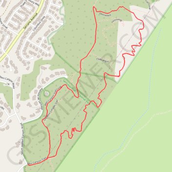
Weir Canyon Trail Loop
Starting near East Overlook Terrace and South Hidden Canyon Road in Anaheim Hills, this Weir Canyon Trail Loop enters the Weir Canyon side of Santiago Oaks Regional Park and climbs along open slopes where coastal sage scrub, grassland, and rolling foothill scenery frame the start of the hike.
After the upper hillside viewpoints and ridge-side junctions, this shorter version of the loop crosses the canyon interior via Deerweed Trail, leaving the wider outer circuit aside before rejoining Weir Canyon Trail.
The return follows the lower side of the canyon past chaparral slopes, oak-lined draws, sandstone features, and broad views across Weir Canyon before closing the loop back toward the starting access.
#Hiking #Loop #Canyon #Nature #Park #Foothills #Views
- Distance: 4.3 Km
- Elevation gain: 152 m
- Maximum elevation: 369 m
- Elevation loss: 152 m
- Minimum elevation: 277 m
Interactive trail map
Make a donation
Gear up for your next adventure:
As an Amazon Associate, this site earns from qualifying purchases at no extra cost to you.
Trail profile
- Distance: 4.3 Km
- Elevation gain: 152 m
- Maximum elevation: 369 m
- Elevation loss: 152 m
- Minimum elevation: 277 m
Make a donation
Gear up for your next adventure:
As an Amazon Associate, this site earns from qualifying purchases at no extra cost to you.
About this trail
Name: Weir Canyon Trail Loop trail, distance, elevation, map, profile, GPS track
End: Weir Canyon Trail, Anaheim, Orange County, California, 92808, United States (33.83046 -117.74416)
Coordinates: 33.83044 -117.74417 33.84079 -117.73512
Make a donation
Gear up for your next adventure:
As an Amazon Associate, this site earns from qualifying purchases at no extra cost to you.