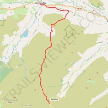
Hike from Kirkstone Pass to Bainbridge via Addlebrough
- Distance: 14.5 Km
- Elevation gain: 268 m
- Maximum elevation: 561 m
- Elevation loss: 467 m
- Minimum elevation: 218 m
- Moving time: 3 h 41 m
- Moving speed: 3.9 Km/h
- Maximum speed: 6.9 Km/h
- Total time: 4 h 14 m
- Global speed: 3.4 Km/h
Interactive trail map
Trail profile
- Distance: 14.5 Km
- Elevation gain: 268 m
- Maximum elevation: 561 m
- Elevation loss: 467 m
- Minimum elevation: 218 m
- Moving time: 3 h 41 m
- Moving speed: 3.9 Km/h
- Maximum speed: 6.9 Km/h
- Total time: 4 h 14 m
- Global speed: 3.4 Km/h
About this trail
Name: Hike from Kirkstone Pass to Bainbridge via Addlebrough trail, distance, elevation, map, profile, GPS track
Coordinates: 54.21927 -2.10469 54.30658 -2.06097