Thank you for supporting this site ❤️
Make a donation
Make a donation
Gear up for your next adventure:
As an Amazon Associate, this site earns from qualifying purchases at no extra cost to you.
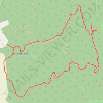
Trappist Abbey - Guadalupe Loop Hike
- Distance: 6.5 Km
- Elevation gain: 283 m
- Maximum elevation: 328 m
- Elevation loss: 282 m
- Minimum elevation: 79 m
Interactive trail map
Thank you for supporting this site ❤️
Make a donation
Make a donation
Gear up for your next adventure:
As an Amazon Associate, this site earns from qualifying purchases at no extra cost to you.
Trail profile
- Distance: 6.5 Km
- Elevation gain: 283 m
- Maximum elevation: 328 m
- Elevation loss: 282 m
- Minimum elevation: 79 m
Thank you for supporting this site ❤️
Make a donation
Make a donation
Gear up for your next adventure:
As an Amazon Associate, this site earns from qualifying purchases at no extra cost to you.
About this trail
Name: Trappist Abbey - Guadalupe Loop Hike trail, distance, elevation, map, profile, GPS track
Start: Guadalupe Loop, Yamhill County, Oregon, 97114, United States (45.28131 -123.08941)
End: Guadalupe Loop, Yamhill County, Oregon, 97114, United States (45.28084 -123.08814)
Coordinates: 45.27364 -123.09000 45.28694 -123.07034
Thank you for supporting this site ❤️
Make a donation
Make a donation
Gear up for your next adventure:
As an Amazon Associate, this site earns from qualifying purchases at no extra cost to you.