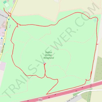
Sutton Manor Woodland Loop Walk
- Distance: 3.7 Km
- Elevation gain: 35 m
- Maximum elevation: 79 m
- Elevation loss: 35 m
- Minimum elevation: 49 m
- Moving time: 57 m 14 s
- Moving speed: 3.9 Km/h
- Maximum speed: 14.8 Km/h
- Total time: 1 h 4 m
- Global speed: 3.4 Km/h
Interactive trail map
Trail profile
- Distance: 3.7 Km
- Elevation gain: 35 m
- Maximum elevation: 79 m
- Elevation loss: 35 m
- Minimum elevation: 49 m
- Moving time: 57 m 14 s
- Moving speed: 3.9 Km/h
- Maximum speed: 14.8 Km/h
- Total time: 1 h 4 m
- Global speed: 3.4 Km/h
About this trail
Name: Sutton Manor Woodland Loop Walk trail, distance, elevation, map, profile, GPS track
Coordinates: 53.40756 -2.72779 53.41468 -2.71477