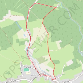
Valire
- Distance: 4.5 Km
- Elevation gain: 107 m
- Maximum elevation: 463 m
- Elevation loss: 107 m
- Minimum elevation: 398 m
Interactive trail map
Trail profile
- Distance: 4.5 Km
- Elevation gain: 107 m
- Maximum elevation: 463 m
- Elevation loss: 107 m
- Minimum elevation: 398 m
About this trail
Name: Valire trail, distance, elevation, map, profile, GPS track
Coordinates: 50.16523 5.71329 50.18048 5.72255
Other hiking, mountain biking, running and outdoor activity trails
Click on a trail to view its statistics, map and profile.
GR005_Parcours-principal_2021-05-06
Netherlands > Limburg > Maastricht
GR005_Parcours-principal_2021-05-06
Distance: 331.2 Km • Elevation gain: 8,983 m • Maximum elevation: 572 m
Riethoven naar Oostenrijk
Netherlands > North Brabant > Riethoven > Eind
Distance: 922.1 Km • Elevation gain: 13,629 m • Maximum elevation: 1,897 m
Eurovelo 15 - Strasbourg Rotterdam
France > Grand Est > Bas-Rhin > Strasbourg
Distance: 891.7 Km • Elevation gain: 2,104 m • Maximum elevation: 146 m
LT25_FINAL
Belgium > Luxembourg > Bastogne > Mont
Distance: 276.0 Km • Elevation gain: 10,191 m • Maximum elevation: 626 m