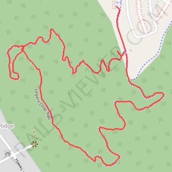
Legacy Loop Trail
- Distance: 3.2 Km
- Elevation gain: 93 m
- Maximum elevation: 330 m
- Elevation loss: 93 m
- Minimum elevation: 239 m
- Moving time: 54 m 42 s
- Moving speed: 3.5 Km/h
- Maximum speed: 5.6 Km/h
- Total time: 57 m 26 s
- Global speed: 3.3 Km/h
Interactive trail map
Trail profile
- Distance: 3.2 Km
- Elevation gain: 93 m
- Maximum elevation: 330 m
- Elevation loss: 93 m
- Minimum elevation: 239 m
- Moving time: 54 m 42 s
- Moving speed: 3.5 Km/h
- Maximum speed: 5.6 Km/h
- Total time: 57 m 26 s
- Global speed: 3.3 Km/h
About this trail
Name: Legacy Loop Trail trail, distance, elevation, map, profile, GPS track
Coordinates: 34.75873 -86.54184 34.76466 -86.53476
Other hiking, mountain biking, running and outdoor activity trails
Click on a trail to view its statistics, map and profile.
25 mile Bike Ride, Huntsville/Gurley AL
United States > Alabama > Madison County > Huntsville > Five Points
Moontown Airport
Distance: 40.5 Km • Elevation gain: 377 m • Maximum elevation: 307 m