Lost Horse Mine
Hike to Lost Horse Mine in the Joshua Tree National Park. #Hiking #Mountain #Nature #Desert #Park
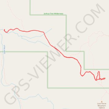
- Distance: 5.5 Km
- Elevation gain: 138 m
- Maximum elevation: 1,569 m
- Elevation loss: 201 m
- Minimum elevation: 1,400 m
- Moving time: 1 h 37 m
- Moving speed: 3.3 Km/h
- Maximum speed: 14.1 Km/h
- Total time: 2 h 25 m
- Global speed: 2.3 Km/h
Interactive trail map
Trail profile
- Distance: 5.5 Km
- Elevation gain: 138 m
- Maximum elevation: 1,569 m
- Elevation loss: 201 m
- Minimum elevation: 1,400 m
- Moving time: 1 h 37 m
- Moving speed: 3.3 Km/h
- Maximum speed: 14.1 Km/h
- Total time: 2 h 25 m
- Global speed: 2.3 Km/h
About this trail
Name: Lost Horse Mine trail, distance, elevation, map, profile, GPS track
Start: Lost Horse Mine Loop Trail, Riverside County, California, United States (33.94860 -116.14925)
End: Lost Horse Mine Road, Riverside County, California, United States (33.95091 -116.15997)
Coordinates: 33.94088 -116.15997 33.95130 -116.13565