Goat Canyon Trestle via Mortero Palms
Hike to Goat Canyon Trestle via Mortero Palms in the Anza-Borrego Desert State Wilderness. #Hiking #Canyon #Nature #Desert #Canyon #Mountain #Wilderness
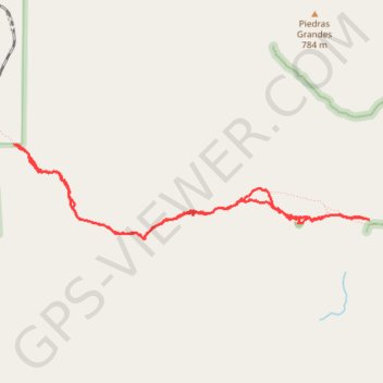
- Distance: 9.1 Km
- Elevation gain: 620 m
- Maximum elevation: 1,005 m
- Elevation loss: 620 m
- Minimum elevation: 608 m
- Moving time: 3 h 43 m
- Moving speed: 2.4 Km/h
- Maximum speed: 7.9 Km/h
- Total time: 5 h 39 m
- Global speed: 1.6 Km/h
Interactive trail map
Trail profile
- Distance: 9.1 Km
- Elevation gain: 620 m
- Maximum elevation: 1,005 m
- Elevation loss: 620 m
- Minimum elevation: 608 m
- Moving time: 3 h 43 m
- Moving speed: 2.4 Km/h
- Maximum speed: 7.9 Km/h
- Total time: 5 h 39 m
- Global speed: 1.6 Km/h
About this trail
Name: Goat Canyon Trestle via Mortero Palms trail, distance, elevation, map, profile, GPS track
Start: Mortero Palms Road, San Diego County, California, United States (32.72031 -116.14669)
End: Mortero Palms Road, San Diego County, California, United States (32.72031 -116.14669)
Coordinates: 32.71868 -116.18102 32.72637 -116.14669